
Ground-Penetrating Radar (GPR)
We are Qatar’s premier service provider of 3D GPR scanning and underground utility detection services.
Qatar Public utility systems and local governments require that the positions of underground systems be located and marked.
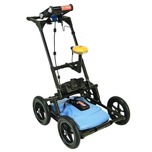
RD1500™ Ground Penetrating Radar is Radiodetection’s flagship GPR for utility locating
Our team of experienced professionals specializes in providing accurate and reliable 3D detection services for a Electrical and communication utility mapping, etc.
We are committed to providing the highest level of service and expertise to our clients, utilizing the latest technology and techniques to deliver reports you can trust.
To learn more about our services and how we can support your project needs, You can also reach out to us directly by replying to this email or calling our customer service team at
- Sensor frequency/250MHz Ultra Wide Band/ RD1500.
- Depth range/ Up to 8m (27′)/ maximum Ground conditions dependent
- Display depth scale 1m-8m (3′-30′)
- Non-metallic pipes, including PVC and asbestos cement
- Underground electrical cable.
Concrete storm and sewer systems. - Metallic and non-metallic utilities.
Utilities where installed tracer wiring has failed. - Underground storage tanks and drainage tiles.
Septic system components. - Non-utility system structures such as vaults, foundation walls, and concrete pads.
- Detect conductive and non-conductive pipes and ducts.
- FrequenSee™ selectively enhances small/shallow, medium size/depth, or large/deep targets, or even all, for easier viewing and detection.
- By recording Grid Scans, users can view not only Line Views but also Depth Slices, greatly increasing the clarity of the collected data.
- The RD1500 includes internal GPS as standard, enabling the unique Map View feature that allows the user to view the path travelled by the system, together with any on-screen markers made.
Advanced Reporting with RD1500 data analysis PC software
- RD1500’s Enhancement Package includes the comprehensive EKKO_Project
PC software solution for GPR data analysis and management, allowing you to: - Slice through the depth data on your computer
- Generate PDF reports that include data images, screenshots and photos
alongside your text and company logo - Export data to other formats like CSV, SEG-Y etc.
3 additional modules to add to the Enhancement Package, for even greater levels
of analysis, are available in Utility Suite: - Line-View modifies and displays GPR lines
- Slice-View processes and displays grid data, and can output data for 3D
visualization and geo-referencing software programs - Interpretation for adding point, polyline, box and annotation interpretations
to GPR lines in post-processing